Friday, September 14, 2018
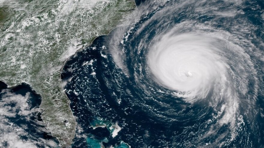
On Friday's Local News Roundup - Hurricane Florence heads toward the Carolina coast with wind, rain, flooding, evacuation all part of this 'monster' storm. We get the latest on the progress of Florence, and what forecasters and emergency preparedness officials believe will be its impact along the coast of both Carolinas and here in Charlotte.
It’s going to be rainy, windy weekend in Charlotte because of Hurricane Florence and, although, we are probably going to miss the worst of this storm, other parts of the state will be seriously impacted.
Over 1.5 million people have been evacuated from the coast. North Carolina has opened over 100 shelters and Charlotte cancelled school so that five of them could be turned into shelters for evacuees and residents should flooding become a problem.
We hear from WCNC meteorologist Brad Panovich to get the latest on the storm and talk with reporters in Charlotte and on the coast about conditions.
Highlights from the show (as of Friday at 9am):
What can we expect in Charlotte today and through the weekend?
WCNC Meteorologist Brad Panovich: In the Charlotte area, we're not going to see any rain during the day today. It's going to be cloudy, breezy and kinda muggy. Our real impacts are going to be the second phase of this storm as it moves inland. Showers should start to move in overnight Friday. The heavy stuff for Charlotte starts to crank up through Saturday into Saturday night, and Sunday into Monday. This is going to be a long-duration event.
The worst weather likely will be during the weekend into early Monday. By the time this is all said and done, we could be looking at rainfall amounts across the Charlotte area of 4-8 inches, with localized amounts approaching 10 inches of rain. That would put this in as one of the highest rain events in Charlotte's history. The hardest part to figure out now is where that heavy rain band sets up - probably right over Charlotte or just to the north. The other threat is wind. We're going to have 30-40 mph winds, coupled with wet ground bringing down the trees, and likely some power lines. And then we have the brief tornado spin-ups that we could see at any time as well.
What should areas outside of Charlotte expect - through the North Carolina mountains, midlands of South Carolina, and to the east of Charlotte?
Panovich: Pretty much everybody from Charlotte east is going to see heavy rain. The mountains haven't been talked about enough. That heavy rain is going to move into the mountains mainly Sunday into Monday. And the topography of the mountains could enhance the rainfall there. We could see totals there around a foot in some locations. That brings in the mudslide and landslide threat as well.
As of this morning at 9am, Hurricane Florence is a slow moving Category 1 storm making landfall in Wilmington. What have we seen so far from this storm on the coast?
Panovich: The wind speeds went down slightly from a Category 2 to a Category 1. But the storm surge and the wind field actually increased. That's what happens at landfall - the storm actually got bigger physically. The tropical storm force winds now extend out 195 miles. That basically became a larger blade on a bulldozer which allowed it to push more water to the coast. So we've seen record storm surge in places like New Bern over 10 feet. And Emerald Isle which approached 8-9 feet. The storm surge in some locations is going to set records.
Don't pay too much attention to the storm's "category" - the fact that Florence is now a Category 1, for example. Focus on the impact on the storm.
Panovich: The thing about hurricanes is the number one killer is storm surge and water. We're going to find out unfortunately that the fresh water flooding issue is going to become a big part of this storm as it moves inland and spreads these record-setting rainfall amounts from the coast all the way into the Charlotte region. Water is our number one concern with these systems.
Don't be fooled by the fact that the storm is weakening as it moves inland. The rain threat is just going up. And it's going to take awhile to get here. Don't let your guard down. This is going to be a delayed impact for us and it will last well into next week.
Guests
Brad Panovich, chief meteorologist at WCNC NBC Charlotte
Nick de la Canal, reporter for WFAE
Shawn Flynn, managing editor for Spectrum News
Ann Doss Helms, reporter for The Charlotte Observer
Reuben Jones, reporter for Spectrum News, reporting from Kinston, NC
Anna Douglas, reporter for The Charlotte Observer, reporting from Myrtle Beach, SC


