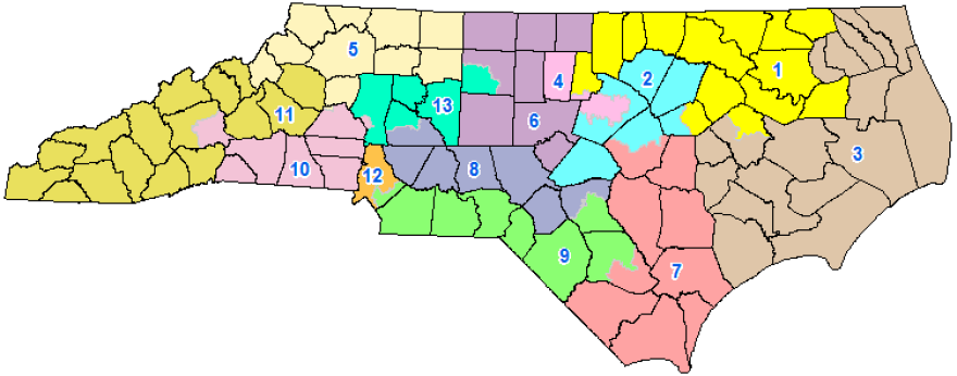
There are two key dates approaching for the fate of North Carolina’s gerrymandered political maps.
The U.S. Supreme Court is expected to rule this summer – possibly next month – on Common Cause vs. Rucho, which says the state’s congressional map is an unconstitutional political gerrymander. In July, a similar case will be heard about the state’s legislative map, though this time in Wake County Superior Court.
If the legislative leadership wins, it’s doubtful anything will change. But if the plaintiffs do win, it would result in new maps – and could encourage the Republican leadership to create some kind of third-party to draw maps. They might decide a somewhat independent group drawing maps would be better than having a chance that the Democrats get a legislative majority in 2020, which would put them in charge.
“Do we want it to be a citizens commission, do we want it to be a politically appointed commission, or do we want it to be nonpartisan staff?” asked Bob Phillips, of Common Cause, which along with the League of Women Voters sued the state over the congressional map.
Phillips brought three members of California’s 14-member Citizens Redistricting Commission to WFAE this week to talk about their decade-long experience in drawing state and federal maps.
The commission was created by a statewide vote. The commission’s mission was to draw maps without using political data, such as party registration.
They were supposed to try to keep cities and counties whole, create compact districts, as well as create so-called communities of interest. That often meant instead of cracking groups of minority voters into several districts, grouping them together to give them a voice.
But communities of interest was not always about race and ethnicity.
Stan Forbes, an independent member of the commission (It has five Democrats, five Republicans and four Independents), said they had created a district in Sonoma County.
“The wine growers said it’s really important that the warehouses be put in our district because that’s such an important part of our industry.” He said. “So we adjusted the lines to incorporate warehouses into the district. When it was appropriate we absolutely paid attention.”
In 2011, ProPublica wrote a story about the early efforts of the California commission. The story said the Democratic Party mobilized activists posing as nonpartisans, who lobbied the commission to get maps favorable for Blue candidates.
Members of the commission said they weren’t fooled. They said Democratic gains in 2010 were due to the party being more of a natural fit for the state.
Cynthia Dai, a Democratic member of the commission, said Republicans were also using the same tactics as Democrats.
And Forbes said the commission understood what was happening.
“They may have tried that, and we believe they probably did,” he said. “But it had no impact. It would be countered by someone else. And we were sufficiently savvy to know when we were being played.”
The group said in the decade before the commission started, there were 265 federal congressional elections in the state. One seat changed hands.
In the 2018 election, seven districts flipped. Democrats won all of those seats and now hold 39 of the state’s 53 seats.
“But by very thin margins,” Dai said.
She and the others said the 2018 results show their maps were effective because it allowed for a swing in the electorate. 2018 was a Blue Wave across the nation, and the maps allowed that to take place in California.
“They are competitive,” Forbes said. “They may flip back next year.”
Dai said if the electorate changes its mind, “the election results will show that.”
North Carolina’s congressional map gives Republicans an advantage because it cracks several cities, including Asheville, Greensboro and Fayetteville. In those cities, Democratic votes are split between two districts.
In Greensboro, the campus of the historically black school North Carolina A&T State University is split in two districts.
“That would never happen in California,” Forbes said.
But what about Mecklenburg County?
In Mecklenburg, white, affluent areas of south Charlotte – along with Mint Hill and Matthews – are placed in the 9th Congressional District. The rest of Mecklenburg is in the 12th Congressional District.
Are those areas of south Charlotte, and Matthews and Mint Hill, a “community of interest?” After all, they are mostly white. They are mostly made of single-family homeowners.
Dai said an argument could “absolutely” be made that those neighborhoods are a “community of interest” – so long as politics wasn’t used to draw the lines.
“California has a definition in the constitution of communities of interest,” she explained. “It says it’s an area that has similar social and economic interest, and should be drawn into one district for the purpose of fair and effective representation.”
And that means that a California-style commission might make North Carolina’s maps more balanced.
But it could still result in people being grouped together by race and ethnicity, which often correlates closely with how people vote.

This article was originally published in WFAE's weekly newsletter "Inside Politics With Steve Harrison." Want more of the story behind the stories? Sign up for "Inside Politics."


