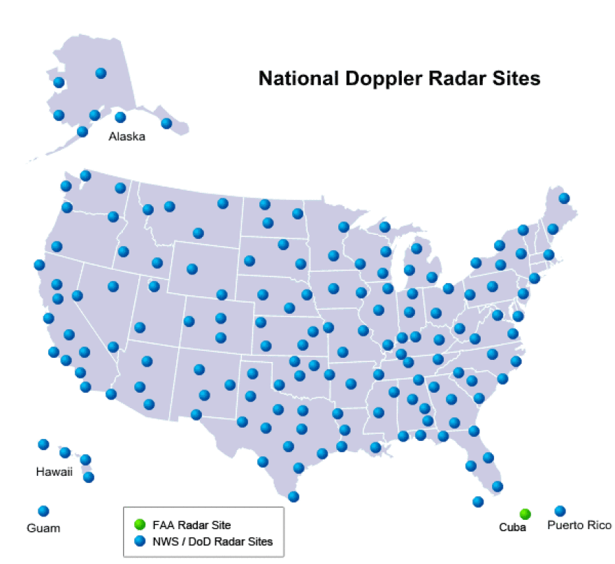
Across the U.S., the National Weather Service operates 122 Doppler radars. These Next Generation or 'NEXRAD' systems, installed in the 1990s, give forecasters powerful tools to track weather conditions including tornadoes and other severe storms.
NEXRAD radars are located in Raleigh, Columbia, and in Greer, South Carolina, west of Spartanburg - but not in or near Charlotte. Some say, that leaves a dangerous gap in radar coverage for the Charlotte region. Legislation now moving through Congress could lead to a change down the road.
Shortly after 2:30 a.m. on March 3, 2012 a tornado touched down in eastern Mecklenburg County and cut a path more than three miles long through residential neighborhoods, into Cabarrus County. Four people were injured, including three young children who the tornado tossed from their house. The National Weather Service (NWS) said almost 200 homes had some impact from the storm, and 29 homes in Mecklenburg County suffered major damage.
The 2012 twister came and went within about five minutes, and NWS issued no tornado warning for the affected area. The storm is one example cited by those who say the current placement of Weather Service Doppler radars leaves much of the North Carolina Piedmont vulnerable to undetected tornadoes.
Doppler radars scan the skies by sending out a straight-line beam, explains Brad Panovich, chief meteorologist for WCNC-TV. "Because the earth curves, the farther out you get form a radar site, the higher up in the atmosphere the beam is," he adds.
By the time the beam from the NWS Doppler radar in Greer, S.C. travels about 80 miles to Charlotte, it's 8,000-9,000 feet up in the air. Panovich says the radar signal is able to detect rain from that distance. "But for severe weather like microbursts or tornadoes, those all occur below the cloud level, so the radar beam will overshoot that."
What about the radar images broadcast by Charlotte TV stations? They come either from the same government radars, or from less-powerful radars owned by the stations themselves. Panovich and other local TV forecasters agree, it's not the same as having a government NEXRAD radar nearby.
The National Weather Service wouldn't provide an interview for this story. But the agency points out that radar is one of many tools its meteorologists use to issue forecasts and severe weather warnings. Resources also include surface observations and data from a smaller Doppler radar that the Federal Aviation Administration uses to spot dangerous storms near Charlotte's airport.
In a statement provided to WFAE, the NWS maintains that its current network of radars provides "comprehensive coverage for severe weather that can threaten the Charlotte area." Steve Harned, who headed NWS operations in North Carolina in the 1990s, agrees. Harned, who now owns a weather consulting firm based in Wilmington, N.C., says the government's NEXRAD weather radars were designed to detect storms as far away as 124 miles.
But would a NEXRAD radar located closer to Charlotte than the Greer, S.C. radar be more likely to detect a tornado forming in the Charlotte area? Harned says, not really - at least for a large tornado. "A big tornado has circulation thousands of feet up in the sky," says Harned. So, for those storms, he says the Greer radar is "quite effective" for allowing forecasters to issue tornado warnings.
Harned says smaller, weaker tornadoes are harder to detect. But for those twisters, he adds, "even if you're within 30-40 miles of the radar, some of those smaller ones will [not be] detected."
Still, critics including 9th district North Carolina Congressman Robert Pittenger say Charlotte is the largest metro area in the country that isn't served by a nearby NEXRAD radar. Noting the presence of NWS Doppler radars serving cities around the country, Pittenger asks, for example, "Why would Raleigh have radar, and not Charlotte? It doesn't make sense."

The original decisions about where to place the new NEXRAD systems in the 1990s involved consideration of radar coverage patterns and budgets. People familiar with the history also recall the role of politics. With influence from then-South Carolina Senator Ernest Hollings, one Doppler radar went to Greer. And, as part of a nationwide restructuring, the National Weather Service closed its Charlotte office in 1996.
Over the years, members of Congress from North Carolina have repeatedly tried, unsuccessfully, to remedy what they've seen as a gap in radar coverage around Charlotte and other parts of the NC Piedmont and foothills. A new effort by Rep. Pittenger has now taken the form of an amendment, which was recently attached to a separate weather-related bill in Congress.
The new legislation would require the federal government to identify any radar coverage gaps around Charlotte or elsewhere, and make recommendations to improve coverage. Pittenger says it's a safety issue, adding, "I'm not gonna wait for somebody to die before we deal with this." The U.S. Senate approved the amended legislation last week, and Pittenger's office says it could return to the House for final approval this week.
For now though, the National Weather Service says it has no plans to install new NEXRAD radars, and has none of the radar available for a new location. The agency says manufacturing a new system would cost at least $10 million.
Funding for any new radars could be tough to come by. The Trump Administration has proposed a 17% budget cut for the National Oceanic and Atmospheric Administration, which oversees the National Weather Service. But Pittenger maintains that providing money for NEXRAD coverage closer to Charlotte should be a funding priority, if a new study proves there's a radar gap that needs closing.


