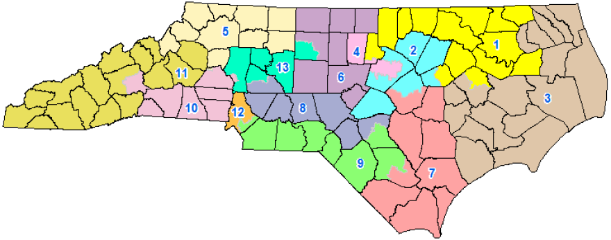
There were two blockbuster rulings Monday about North Carolina’s political maps. One upheld newly redrawn state legislative maps for the General Assembly. The other ruling threw out — for now — the state’s congressional map, which was drawn to give Republicans the advantage in 10 of 13 congressional seats.

WFAE politics reporter Steve Harrison joins "Morning Edition" host with more details on these two rulings.
Lisa Worf: Steve, let’s start with the congressional map. What does this mean for the 2020 election coming up?
Steve Harrison: It means everything. But first let’s back up a little bit.
This summer, opponents of gerrymandering in North Carolina were crestfallen when the U.S. Supreme Court ruled against them. The highest court said, "OK, gerrymandering is bad for democracy, but it’s not our job to police it." That’s better left for state courts and state legislatures.
So, in North Carolina, that’s where the battle shifted. And since then, the plaintiffs – a mix of voters and the group Common Cause – have had a series of wins.
And they got another win yesterday, when a three-judge panel in Raleigh blocked the use of the state’s congressional maps – pending a final decision.
As for the 2020 elections, this changes everything. The primaries are the first week of March, so that’s four months away. Filing starts in December.
[RELATED: NORTH CAROLINA JUDGES THROW OUT CURRENT CONGRESSIONAL MAP]
Worf: So, let’s talk for a minute about the current congressional map. Republicans have the advantage, with 10 seats. How was it drawn to give them an edge?
Harrison: The two key words with this map are cracking and packing.
In a lot of cities, the General Assembly cracked Democratic voters into two congressional districts to dilute their strength. Republicans did this in Fayetteville and probably most famously in Greensboro, where the campus of North Carolina A&T is split into two districts.
And the other strategy is packing as many Democratic voters into a safe Democratic seat as possible. That’s what happened in Mecklenburg County. Alma Adams represents the 12th District, which includes all of Mecklenburg – except for a wedge of Charlotte, along with Matthews and Mint Hill, which have historically voted for Republicans.
Worf: OK, so let’s say this ruling is upheld. Do we know it would impact individual representatives?
Harrison: It's too early to know how the maps would be drawn and what criteria would be used. For instance, would they try to divide counties if it all possible?
But here’s an example.
Let’s look at Mark Meadows. He’s a conservative who represents the 11th District in the mountains, and he’s become one of the president’s closest allies in Congress.
And Meadows can do that because of how his district was drawn. The 11th District covers western North Carolina, but if you look closely, you’ll see a hole, so to speak, in his district. And that hole is the city of Asheville and Black Mountain beside it.
So last year Meadows easily won reelection, getting nearly 60% of the vote. But he didn’t have to deal with Democratic Asheville voters.
So, if you put Asheville in that district, suddenly being one of the most pro-Trump congressmen isn’t such a sure path to reelection.
And remember Health Shuler, the former quarterback who held that seat before Meadows? He was a Democrat. And when he won, the 11th included Asheville.
Worf: OK, what about close to home in Charlotte. What might change here?

Harrison: Mecklenburg has two congressional districts – the 12th, which is where Democrats were packed together, and the 9th District. The 9th starts in Charlotte and then goes east all the way to Bladen County, which is pretty close to the beach.
It’s probably safe to say that if new maps are drawn, Charlotte and Bladen County will not be in the same congressional district. It’s just too far away.
In today’s 9th District, President Trump won it by 12 percentage points, and then Republican Dan Bishop narrowly beat Democrat Dan McCready in September by 2 points.
So, would it become more Democratic? Probably so. Remember, in terms of seeing who might run, when you run for Congress you don't have to live in your district.
Worf: What have the Republicans said about yesterday’s ruling. Are they going to appeal?
Harrison: What we know is that this case is going to stay in state court – and that’s a win for Democrats – because the state Supreme Court has a 6-1 Democratic advantage.
When the three-judge panel ordered the state’s legislative maps redrawn, the GOP did not fight it. They quickly produced new maps in two weeks that Democrats and Republicans both said were pretty fair.
And those maps were approved yesterday by the same judges. So that part of the gerrymandering fight is over.
So, to back up – we don’t know yet what the Republicans are going to do.


