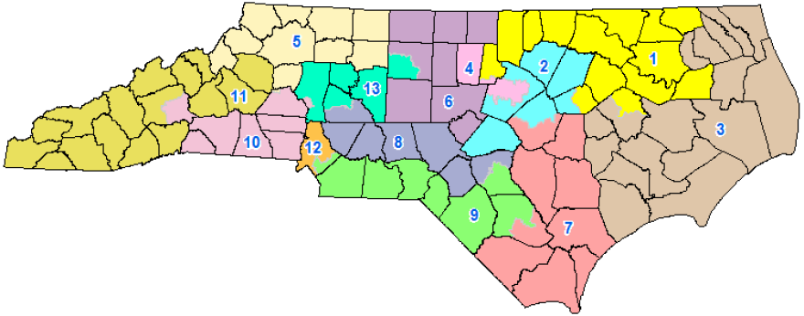
After a three-judge panel Oct. 28 said North Carolina’s gerrymandered congressional map couldn’t be used for filing that begins in December, the Republican leadership formed a bipartisan committee to draw a new map.
The General Assembly did something similar when the same judges ordered them to create new state House and Senate maps, and the process of making a new map was generally deemed fair by Democrats and Republicans.
But after two days of congressional mapmaking by Democrats and Republicans, some observers are horrified at the maps that have been produced, even if they aren’t final.
“This is the epitome of bad faith,” said attorney Allison Riggs, who argued a North Carolina gerrymandering case before the U.S. Supreme Court in March. “These guys aren’t even trying.”
Riggs said the efforts to make new maps are “offensive.”
Riggs argued her gerrymandering case on behalf of the League of Women Voters. And though the highest court ruled against the League and Common Cause, Chief Justice John Roberts said state courts and legislatures should police gerrymandering.
And that is what’s happened in North Carolina, both at the state and congressional level.
A spokesperson for Republican state Sen. Ralph Hise said the process is being "muddled" by competing lawsuits. The three-judge panel has not yet definitely ruled that the state needs a new map, and the same court has not given the state guidelines on how to move forward.
"We are currently under a state court's 'wink-and-nod' quasi-order that says they haven't gone through enough process yet to determine that the current Congressional maps violate the North Carolina Constitution, but they 'urge' us to go ahead and create new maps," Hise said in a statement.
"We're going to move forward and begin the redistricting process because the filing period starts in less than one month, whether under the current map or a new one. We intend to keep the state on schedule and not cram the election process. But we're in a difficult place with no clear direction on which way to go."
When making new state legislative maps, legislators started with a computer-generated map and then adjusted it to make sure legislators were not placed in the same district.
Legislators are making the congressional maps by hand. Or, more accurately, by using a mouse to click on different counties and precincts to create districts.
On some maps, the results are districts that are even more unusual than the gerrymandered districts they are supposed to replace.
The current congressional map is notorious for splitting Greensboro in two, for taking Asheville out of Mark Meadows’ western district and for the “Mecklenburg Boot” of historically GOP-leaning precincts that were placed in the 9th District.
One map posted on the General Assembly website is the “Willingham Map.” Shelly Willingham is a Democratic House member from Rocky Mount.
That map made some sensible changes, like putting Asheville in Mark Meadows’ western North Carolina district.
But Mecklenburg is more of a mess then before.
The state’s largest county – which could almost be home to its own congressional district – is chopped into three districts.

To give Republican Dan Bishop his own district, the map has a narrow corridor of south Charlotte precincts, as though it were a finger.
Republican Rep. David Lewis infamously said the legislature drew a map that gave Republicans a 10-3 advantage because they couldn’t draw a map that gave Republicans the advantage in 11 seats.
He’s a committee member, and he has also produced a draft map.
That map recreates the “Mecklenburg Boot” that makes the rest of Mecklenburg County overwhelmingly Democratic.
It chops up Guilford County, and it puts Wake County into three districts.

Riggs calls the proposed 4th District an “outrageous” gerrymander.
In the Lewis map, the 4th District is in yellow and covers Alamance and Orange counties and part of Wake County.
She also says the legislature’s decision to give each representative their own district is misguided. You don’t have to live in your district to run for Congress, and drawing districts on the account of representatives produces disjointed districts.
“They haven’t done this is in the past,” she said. “They drew Alma Adams out of her district in the past.”
She said it’s possible the three-judge panel could throw out whatever map the General Assembly produces and would appoint a special master to make a new map.
“They could fix this now,” she said. “But they are choosing not to.”
This story originally appeared in the Nov. 8 issue of WFAE's Inside Politics newsletter. You can sign up here to get WFAE politics reporter Steve Harrison's analyses of political issues in your inbox every Friday.


